|
| |
 The Domesday book records that William holds 2 hides from
the Count of Mortain, that the land supports 6 ploughs, and
5 villeins. There were also 17 salt workings nearby. This area
was badly affected by the Norman invasion, and was valued at
125 shillings before 1066 and 50 after. The Domesday book records that William holds 2 hides from
the Count of Mortain, that the land supports 6 ploughs, and
5 villeins. There were also 17 salt workings nearby. This area
was badly affected by the Norman invasion, and was valued at
125 shillings before 1066 and 50 after.
In 1252, Henry III granted the right to hold a market. Some
of the tolls taken during the Hundred Years War with France
were used to pay for the garrison at Pevensey. This market
continued until 1639, when it was discontinued, but re-started
in the late 1700's. The market changed its focus to livestock
and it is known that welsh farmers brought their cattle for
selling at Hailsham in East Sussex.
The numbers of livestock in Hailsham together with the number
of local oak trees(tannin from the bark is used in the process)
provided tanners and leather workers with a great deal of wealth
The population increased to the 300 mark by the mid 1600's
but increased significantly from about 1000 in the early
1800's to 3500 by the 1890's. This was mostly due to the
manufacture of rope which was started in 1780 by
Thomas Burfield . The term rope walk comes from the spinning
process used in rope manufacture, where by Spinners would
walk down a straight path letting out hemp, which was spun
by wheelboys turning a wheel.
In 1803 Hailsham Barracks were built to quarter troops
intended to man the Martello towers which defend the
Pevensey area from Napoleon. The Barracks were closed
after the defeat of Napoleon at Waterloo in 1815.
During the 1800's a wide range of rope related goods
were manufactured in the vicinity, including Hop Pockets
for the brewing industry, cloths, twine, mill sails and
whip cord, and ropes for the navy.
One example of the work of Jonathan Harmer of Heathfield
can be found in the churchyard, a large stone chest type
grave with a terracotta plaque attached. This example of
his craft comes from the early 1800's.
In 1849 a branch train line was built from Polegate
to Hailsham, then extended on to Eridge via Heathfield
in the 1880's, and was known as the Cuckoo Line from
the legend . The line was closed in 1965, and is now
the Cuckoo Trail , a footpath and bridleway running from
Polegate to Heathfield .
Hailsham also used to produce Sussex Trugs, now only
manufactured at nearby Herstmonceux . |
|
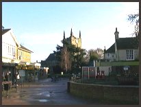
 The High Street has a natural charm, and if you walk down from
the northern part of the town, the church, especially on a
bright sunny day stands out in front of you. The High Street has a natural charm, and if you walk down from
the northern part of the town, the church, especially on a
bright sunny day stands out in front of you.
If you carry on into the churchyard, carry on through, and turn
left, then walk down Marshfoot Lane, you can see many views across
the Pevensey Levels. |
|
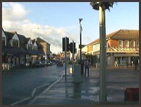
 Hailsham in East Sussex is one of those small towns with a wide range of shops,
and is the centre for many villages surrounding.
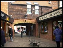
The High Street is the main shopping area, with the precincts
of Vicarage Field, and Quintins providing additional shops
attached to the High Street. Hailsham in East Sussex is one of those small towns with a wide range of shops,
and is the centre for many villages surrounding.
The High Street is the main shopping area, with the precincts
of Vicarage Field, and Quintins providing additional shops
attached to the High Street.
Hailsham has its own Leisure Centre, the Lagoon with a swimming
pool, and other facilities.
Major supermarkets are to be found in Eastbourne about 5 miles
south. The nearest trains run from Westham to Hastings and Brighton . |
|
| Hailsham is shown as the red symbol on the map. |
|
|
Nearby Villages
(click on symbol to see the village page) |
| Village= | |
Town= | |
Recorded in Domesday= |  |
| |
|
|
Alciston |
(Fifty thousand tiles on the Barn) | | 5.78 miles |
|
|
Alfriston |
(Smuggling and Ghosts) | | 5.85 miles |
|
|
Arlington |
(Peaceful Saxon Village) | | 3.04 miles |
|
|
Ashburnham |
(Last Iron Furnace in Sussex) | | 6.76 miles |
|
|
Berwick |
(Sharpen your arrows on the Church) | | 5.34 miles |
|
|
Bodle Street |
(White Horse on the roof) | | 5.14 miles |
|
|
Boreham Street |
(Picturesque village on top of the Ridge) | | 4.98 miles |
|
|
Chalvington |
(The miniature church) | | 4.18 miles |
|
|
Chiddingly |
(Walking on Cheese ??) | | 3.96 miles |
|
|
Folkington |
(Teasles and Badgers) | | 4.05 miles |
|
|
Hellingly |
(Only remaining Ciric in Sussex) | | 1.71 miles |
|
|
Herstmonceux |
(Castle and Observatory) | | 3.41 miles |
|
|
Hooe |
(The Haunt of Smugglers) | | 6.56 miles |
|
|
Laughton |
(Knight captures King of France) | | 5.79 miles |
|
|
Normans Bay |
(Last Invasion in 1066) | | 6.67 miles |
|
|
Pevensey |
(Ancient Roman Fortification) | | 4.79 miles |
|
|
Pevensey Bay |
(Fishing and Martello Towers) | | 5.06 miles |
|
|
Polegate |
(Fine old Tower Mill) | | 2.87 miles |
|
|
Ripe |
(Earl Harolds estate) | | 4.92 miles |
|
|
Selmeston |
(Tomb to store the Contraband) | | 5.07 miles |
|
|
Wartling |
(World War II defence centre) | | 4.37 miles |
|
|
Westham |
(Enclosure for the Castle) | | 4.54 miles |
|
|
Wilmington |
(The Long Man) | | 4.28 miles |
|
|
Windmill Hill |
(Largest Post Mill in Sussex) | | 4.04 miles |
|
|
| |
 The Cuckoo Line was the old steam railway which ran from Polegate
to Tunbridge Wells.
The Cuckoo Line was the old steam railway which ran from Polegate
to Tunbridge Wells.
The track was started in 1849 with the single track link
from Polegate to Hailsham . In September 1880 a further
length of single track line from Eridge to Hailsham was opened,
providing a service from Charing Cross to Eastbourne via
Tunbridge Wells .
The track ran from Polegate to Tunbridge Wells via Hailsham ,
Hellingly , Waldron , Horam Road , Heathfield through a tunnel
to Mayfield , Rotherfield then on to Eridge where it joined
the Uckfield to Tunbridge Wells line.
Its name came from the Cuckoo Fair held at Heathfield.
Legend has it that a quaintly dressed old lady always
turns up at the annual April Heffle( Heathfield ) Cuckoo
Fair, to release from her basket the first cuckoo of spring.
Drivers of the trains referred to the trip as "going down
the Cuckoo".
The majority of the traffic on the line was from the Express
Dairies milk plant at Horam .
In 1895 Heathfield station was famous due to being the first to
be natural gas lit, no others stations were so illuminated prior
to the First World War, the gas continued to flow till the 1930's.
The gas was discovered, by the Railway company looking for water
near the station to fill the steam train water tanks.
Horam station must have been confusing to passengers, as it had
a number of names starting with "Horeham Road" then "Waldron",
"Horeham Road - Waldron", "Waldron - Horeham Road", "Waldron - Horam"
and finally in 1953 "Horam".
Today the Heathfield to Polegate section has been opened up to
the public for walking, cycle riding, and in some sections as
a bridleway, and is known as the Cuckoo Trail . |
| |


